Day 170: How many people do you know who would drive 70 miles and hike through muddy trailless forest just to get a better picture of a botanical specimen? Mind you, I said "a better picture." The ones I took last week weren't quite as well-focused as I would have liked. They were sufficient that when I sent one off to an expert who in turn sent it off to another expert, she was able to return an identification to me, but in my book, the picture just wasn't "blogworthy." The specimen wasn't anything rare, just...odd. You'll see it in an upcoming post.
As long as I was going to have to go halfway up the hill, I figured I'd attack the remaining distance to the falls to do some maintenance on a geocache for a friend. The cache used to be mine; I turned it over to him several years ago. He never gets up to the falls but I do, so it makes sense for me to take care of it. I also had another job in mind. The local "party boys" get up there every now and then, and inevitably, there's some trash to take out. I hadn't been equipped to do that last week, but yesterday, I went prepared. I also wanted to remove about 30' of heavy-duty tie-down strap they'd been using as a rappelling rope to get down the last slope. I don't rappel. Why should they? If they want to mess up the site, they're going to have to work harder at it now.
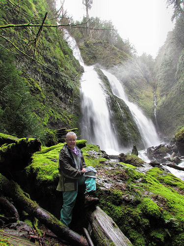
I overexposed the falls in this photo in an attempt to bring the foreground out, but even so, I had to pull the shadows up substantially, particularly on my face. It's DARK in there! The walls of the canyon are very close and high, and I doubt if direct sunlight hits that rock more than half an hour a day on more than 14 days per year. Everything is covered in a thick layer of slippery, wet moss except the newer wood which has been carried over the falls during heavy rain. But there is a mystery I have yet to solve: what is the source of Sulphur Creek? On the topo map, it looks like a small drainage nourished by nothing more than runoff which, incidentally, goes two ways from the spine of Green Mountain Road. To the north, it drains into Swofford Pond (subsidiary to larger Riffe Lake). To the east, it drains immediately into Riffe. There is no lake feeding it, but it never goes completely dry. Unfortunately, all the land above it is privately held, so I can't go exploring. I guess there are some things we're just not meant to know.
No comments:
Post a Comment